The most beautiful largest glaciers in the world. Glaciers of Russia: list and photos
Speaking about the largest glaciers in the World, it is worth mentioning that they exist in several types: corvettes, valley glaciers, cover glaciers, etc. The vast majority of glaciation on Earth belongs to ice caps Antarctica and Greenland, that is, to cover glaciers. I would just like to note that the thickness of the ice there reaches enormous levels - more than 4 km.
Large ice caps are found on the islands Canadian Arctic Archipelago. They amount to tens of thousands of square kilometers. Huge ice fields follow them Spitsbergen.
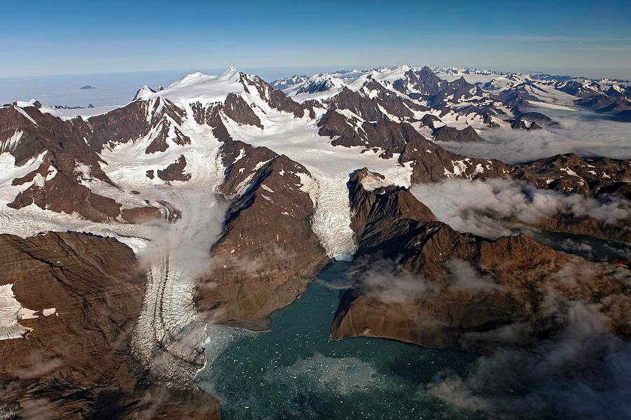
Approximately 50 percent of the total area Northern Island of the Novaya Zemlya archipelago majestic glaciers have been reclaimed. On an area of almost 20,000 km2 there is a continuous ice shell, which has a length of 400 kilometers and a width of 70-75 kilometers. At the same time, the thickness of the ice is more than 300 meters. In some places the ice goes into the fjords or breaks into the sea, forming icebergs.
Vatnajökull(oh, those Scandinavian names!) is the largest glacier on the island of Iceland. It is located in the southwestern part of the island and occupies 8% of its territory, or 8,133 km2.
Jostedalsbreen Glacier is the largest continental glacier in mainland Europe, covering an area of 487 km2. Located in Norway. It has more than 50 branches, including the famous glaciers Briksdalsbreen and Nigardsbreen.
South America
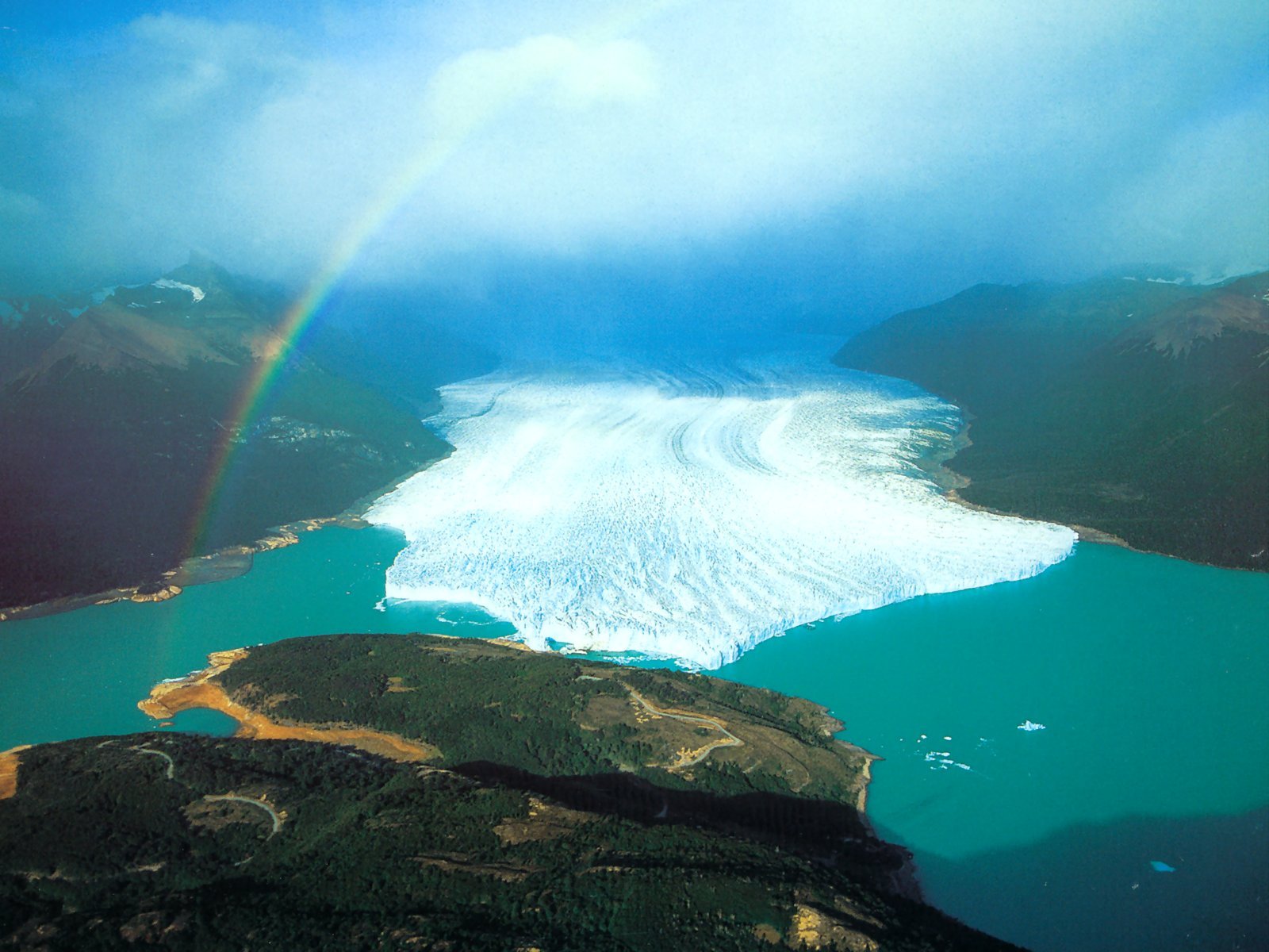
Now let's move from northern Europe to South America. Patagonian Ice Plateau is no less amazing. It consists of two parts: the North, spread over an area of 7,600 km2, and the South, over an area of 12,000 km2. The prevailing surface heights are about 1500 m. Rocky peaks and mountains rise among the ice ( highest point– Bertrand town, 3270 m). At the level of the glacial plateau, 7000–8000 mm of precipitation falls per year. Outfall glaciers flow from the plateau, many on the eastern side ending in fjords, and on the west - in lakes. The largest of them Perito Moreno and Uppsala. The first has an area of 250 km2. The width of the tongue is 5 km, average height- 60 m above the water surface. The speed of its movement is 2 m per day. However, the mass loss is approximately the same, so the glacier tongue has not retreated or advanced for 90 years. The length of the Uppsala glacier is 60 km, width up to 8 km, area 250 km2. Descends into the northern arm of Lake Lago Argentino.
North America
Now it's North America again. We have already spoken about the Canadian Arctic Archipelago. Another place where large glaciers accumulate is Alaska. Bering Glacier- the largest mountain (tree-like) glacier North America. It originates from the ice fields on the Chugach (4116 m) and St. Elias (5489 m) mountains in Alaska (USA). Length (from the most distant source) 203 km, area about 5800 km2. It emerges on the low-lying coast of the Gulf of Alaska, where it forms a foothill ice blade about 80 km long and 43 km wide.
Malaspina- a foothill glacier on the southern coast of Alaska, between Yakutat Bay and Ice Bay. Area 2200 km2. Formed by several glacial streams descending from the St. Elias Mountains. The feeding area is the Seward glacial basin, located at an altitude of 1500-2000 m. Since the 30s of the 20th century, the glacier has been shrinking, retreating from the ocean coast, leaving a shaft of the terminal moraine, gradually overgrown with coniferous forest.
Alaska's glaciers are no less impressive Hubbard(length 122 km) and Colombia(length 66 km, area 1370 km2). The vast firn fields of the latter lie at altitudes of about 3600 m, and the main trunk of the glacier, 4 km wide, reaches Pacific Ocean in Prince William Sound.
High mountain valley glaciers
Previously, we talked about glaciers at high latitudes that feed at relatively low altitudes. Now let's turn our attention to the glaciers located in the highest mountain systems of the world. These are typical mountain-valley glaciers. Although most of them have a complex tree-like structure and many tributaries, they are distinguished primarily by their long valley tongue.
Oddly enough, the highest mountain range on earth has relatively small glaciers. Glaciers of the Himalayas c do not exceed a length of 30 km (Gangotri glacier - 26 km, Zemu glacier - 25, Rongbuk glacier - 19 km).
The largest number of large glaciers are located in mountain system Karakoram. These include Baltoro, Siachen, Biafo. We will turn to them a little later, but now we will turn our attention to one of the most interesting and largest glaciers in the world - Fedchenko.
Pamir
Fedchenko Glacier, the first largest in the CIS and one of the largest glaciers in the world: its length is 77 km, width - from 1700 to 3100 m. It is located in Tajikistan, in the Pamirs. The glacier originates at the foot of Revolution Peak on the northern slope of the Yazgulem ridge and flows along the eastern slope of the Academy of Sciences ridge. The ice thickness in the middle part of the glacier reaches 1000 m, the total area of glaciation and snowfields is 992 km2. The upper end of the glacier is at an altitude of 6280 m, and the lower end is at 2900 m, the height of the snow line is 4650 m. The Seldara River flows out of the glacier.

The history of the discovery of the glacier goes back to the end of the 19th century. In 1871, the first Russian expedition, led by A.P., arrived in the Pamirs. Fedchenko (famous naturalist and explorer of Turkestan). The expedition outlined the general outline of the Pamir ridges, exploring the Trans-Alai ridge in more detail and discovering the highest peak of this ridge (now Lenin Peak - 7134 m). At the same time, the expedition also discovered a huge glacier, now bearing the name Fedchenko. In the basin of this glacier there are the highest peaks of the Pamirs, with their celestial height and inaccessibility attracting the attention of domestic and foreign climbers. In the upper reaches of the glacier, Revolution Peak (6974 m) is located; almost anywhere on the glacier you can see the highest mountain peak the former USSR and the second in the Pamirs - Communism Peak (7495 m). Near Communism Peak are Russia Peak (6852 m) and Garmo Peak (6595 m). Currently, the highest hydrometeorological observatory in the world (more than 4200 m) is located on the Fedchenko glacier.
Karakoram
As already mentioned, the largest number of large high-mountain glaciers are located in the Karakoram mountain system. These include: Siachen, Baltoro, Biafo. Baltoro is located in the Central Karakoram southeast of the city of Chogori (K2) - the second highest peak in the world (8611). The length of the glacier is 62 km, area 750 km2. According to some data, the glacier's area is 1227 km2 and if these figures are correct, then they are larger than that of the Fedchenko glacier (992 km2). Siachen- valley tree-like glacier in Karakoram (India). Length 76 km, area about 750 km2. It flows from the eastern slope of the Konduz ridge at the junction with the Karakoram watershed ridge at altitudes of up to 7000 m. The glacier flows to the east, and over a long distance is partially (in some places completely) covered with a cover of rock fragments; ends at an altitude of 3550 m. Biafo Glacier located on the southern slope of the Karakoram. Length about 68 km, area 620 km2.
Tien Shan
South Inylchek- the largest glacier in the Tien Shan and the second largest mountain glacier in the CIS countries after the Fedchenko glacier in the Pamirs. It is located between the Tengritag and Kokshaaltau ridges. Its length is 58.9 km, area 567.2 km2. The glacier originates in the Khan Tengri region, and its tongue drops to 2800 m. Southern Inylchek flows several kilometers to the north, and then turns sharply to the west. The thickness of the ice in the lower parts of the tongue is 150-200 m. The powerful left tributaries of the glacier, located in the northern spurs of the Kokshaaltau ridge, have their own names: Zvezdochka, Dikiy, Proletarsky tourist, Komsomolets (from east to west). If you look at the glacier from above, it looks like a blue-white tree with longitudinal dark stripes of median moraines on its main trunk and a series of light branches of varying lengths and thicknesses. The largest of the tributary glaciers are the Zvezdochka and Dikiy glaciers.
Alps
Great Aletsch Glacier, located on the southern slope of the Bernese Alps in Switzerland, is the largest glacier in the Alps, covering an area of 87 km2, and taking into account the area of the four firn basins that feed it, about 117 km2. The total length of the Aletsch glacier is about 24 kilometers. Thickness up to 900 m.
Caucasus
Bezengi- a complex valley glacier, the largest in the Caucasus. Located on the northern slope of the Main Range at the foot of the Bezengi Wall. It descends from the peaks of Shkhara and Dzhangitau to a height of 2080 m and serves as the main source of the Cherek-Bezengisky River. Length 17.6 km, sq. 36.2 km2. Firn line at an altitude of 3600 m. The lower 5 km of the glacial tongue are covered with melted debris. From 1888 to 1966, the tongue retreated by 1115 m, and currently continues to retreat. More than 10 of its former tributaries have turned into independent glaciers. Bezengi is followed by the Dykh-Su glaciers (length 13.3 km, area 34.0 km2) and Karaug (length 13.3 km, area 26.6 km2).
Altai
The entire Altai glaciation taken together is nothing more than one of the largest valley glaciers in the world. Although the same can be said about the Caucasus. But even so, the largest glaciers in Altai are impressive. Potanin Glacier(Potanin-Musen-Gol) has an area of 38.5 km2 and a length of 11.5 km. Its vast snow field is surrounded by five peaks arranged in a horseshoe shape. On the right, the Potanin glacier receives 2 glacial tributaries - the upper smaller and lower larger Alexandra glacier (A.V. Potanina). On the left side of the glacier there is a single small tributary. The tongue of the Potanin glacier has a slight slope; There are cracks only in the middle reaches. It descends to an altitude of 2900 m, the lower part is covered with moraine. Melt water flows into the Tsagan-Gol river basin. Glacier V.V. discovered Sapozhnikov in 1905 and named by him in honor of G.N. Potanin.
Taldurinsky glacier (Big Taldurinsky) lies on the elephants of the South Chuya ridge. Length 7.5 km, area 28.2 km2. The height of the end of the glacier is 2450 m. The thickness of the ice reaches 175 m. It is the largest glacier in the Russian Altai. It originates in the circus, framed by peaks about 4000 m high (Iiktu and others). It has a narrow exit to the northeast, into the valley of the Taltura River.
Sapozhnikov Glacier (Mensu)- the largest in the Katunsky ridge of Altai (descends from the slopes of Belukha) its length is 10.5 km, area - 13.2 km2.
The most unique, famous glaciers.
The glacier is approximately 62 km long, making it the longest glacier in the world outside the polar regions. The glacier is located in the Gilgit-Baltistan region of Pakistan. Baltoro is surrounded by the Karakoram Mountains and is located between the Baltoro Muztagh ridge from the north and the Masherbrum ridge from the south, the most high mountain in this area K2 (8611 m). The lower part of the glacier is located at an altitude of 3400 m above sea level, followed by the melting zone of the glacier, which gives rise to the Biafo River.
Antarctica contains the largest amount of ice, and therefore the largest amount of fresh water on the planet. The maximum thickness of ice on the continent is 4800 meters, the average thickness of ice covering the continent is 2600 meters. Moreover, in the central part of Antarctica the ice thickness is greater, and towards the coast it is less. The ice seems to flow from the continent into the ocean. When the ice reaches the ocean, it breaks off into large pieces called icebergs.
The volume of glaciers is 30,000,000 square kilometers, which is 90% of all ice on the planet.
The Kilimanjaro Glacier is not one of the largest glaciers, but its uniqueness is that it is located near the equator in Africa. The Mount Kilimanjaro glacier was formed 11,700 years ago. Since 1912, observations have been made that the area of the glacier began to gradually decrease.
By 1987, the glacier's area had decreased by more than 85% compared to 1912.
Now the absolute area of the glacier is less than 2 square meters. km. According to scientists, the glacier will completely disappear by 2033.
Aletsch Glacier
The Aletsch Glacier is the largest glacier in the Alps. Its length is 23 km, the area of the glacier is 123 square kilometers. The glacier includes 3 adjacent small glaciers. The maximum ice depth is 1000 meters. The glacier has been included in the list since 2001 World Heritage UNESCO (object no. 1037bis).
 |
 |
 |
Harker Glacier is located on South Georgia Island in the South Atlantic Ocean. The uniqueness of the Harker Glacier is its method of formation. This glacier is a tidal glacier. Discovered in 1901 by a Swedish expedition led by Otto Nordenskiöld and Karl Anton Larsen. The glacier is quite stable in its area and volume, although its outline changes over time.
Jostedalsbreen Glacier
The Jostedalsbreen Glacier is the largest glacier in continental Europe. The length of the glacier is 60 km, the area is about 487 square kilometers. Like most other glaciers in the world, Jostedalsbreen is gradually decreasing in size and volume. In 2006, one of the glacier's branches shrank by 50 meters in a few months.
Vatnajökull Glacier
The Vatnajökull glacier is located in Iceland, it is the largest glacier in Europe, so its area is 8100 square kilometers, the volume of the glacier is estimated at 3100 cubic kilometers. The glacier covers volcanoes, and inside the glacier there are caves formed by geysers - hot springs of water. The maximum ice thickness is about 1000 meters.
Hubbard Glacier is located on the border of Alaska and Canada. The glacier was discovered in 1895. The length of the glacier is 122 kilometers. The glacier ends up in Yakutat Bay. The height of the ice in the bay reaches 120 meters above sea level, the width of the glacier near the bay is from 8 to 15 kilometers, depending on the time of year.
The Franz Josef Glacier is located in New Zealand. The glacier is 12 kilometers long and was discovered in 1859. The glacier has phases of increase and decrease; after 2010, it entered an active phase of decrease (retreat).
 |
 |
 |
The Perito Moreno Glacier is located in the southwestern part of the province of Santa Cruz, Argentina.
The length of the glacier is about 30 km, the area of the glacier is 250 km. square. The glacier moves along the mountain slopes to Lake Argentino at a speed of about 2 meters per day. Periodically, a glacier covers the lake, dividing it into 2 parts. The water in the southern part of the lake, due to rivers and streams, begins to rise compared to the northern part. The difference in levels is more than 30 meters, under the influence of water pressure, the isthmus collapses, and streams of water rush into the northern part of the lake.
Glaciers are an extraordinary miracle of nature that slowly moves across the surface of the Earth. This cluster eternal ice on its way it captures and transports rocks, forming unique landscapes such as moraines and cirques. Sometimes the glacier stops moving and the so-called dead ice forms.
Some glaciers, moving a short distance into large lakes or seas, form an area where they break up and, as a result, drift icebergs.
Geographical feature (meaning)

Glaciers appear in places where the accumulated mass of snow and ice significantly exceeds the mass of melting snow. And after many years, a glacier will form in such a region.
Glaciers are the largest reservoirs of fresh water on Earth. Most glaciers accumulate water during the winter season and release it as meltwater. Such waters are especially useful in mountainous regions of the planet, where such water is used by people who live in areas where there is little precipitation. Glacier meltwater is also a source for the existence of flora and fauna.
Characteristics and types of glaciers

According to the method of movement and visual outlines, glaciers are classified into two types: cover (continental) and mountain. Ice sheet glaciers occupy 98% of the total area of planetary glaciation, and mountain glaciers occupy almost 1.5%
Continental glaciers are giant ice sheets located in Antarctica and Greenland. Glaciers of this type have flat-convex outlines that do not depend on the typical topography. Snow accumulates in the center of the glacier, and consumption occurs mainly on the outskirts. The ice of the cover glacier moves in a radial direction - from the center to the periphery, where the ice that is afloat breaks off.
Mountain-type glaciers are small in size, but of different shapes, which depend on their content. All glaciers of this type have clearly defined areas of feeding, transportation and melting. Nutrition is carried out with the help of snow, avalanches, a little sublimation of water vapor and snow transfer by the wind.
The largest glaciers

The largest glacier in the world is the Lambert Glacier, which is located in Antarctica. The length is 515 kilometers, and the width ranges from 30 to 120 kilometers, the depth of the glacier is 2.5 km. The entire surface of the glacier is cut by a large number of cracks. The glacier was discovered in the 50s of the twentieth century by the Australian cartographer Lambert.

In Norway (Svalbard archipelago) there is the Austfonna glacier, which leads the list of the largest glaciers in the Old Continent by area (8200 km2).

(Vatnajökull Glacier and Grimsuod Volcano)
In Iceland there is the Vatnajökull glacier, which ranks second in Europe in terms of area (8100 km2). The largest in mainland Europe is the Jostedalsbreen glacier (1230 km2), which is a wide plateau with numerous ice branches.
Melting glaciers - causes and consequences

The most dangerous of all modern natural processes is the melting of glaciers. Why is this happening? The planet is currently heating up - this is the result of the release of greenhouse gases into the atmosphere that are produced by humanity. As a result, the average temperature on Earth also rises. Since ice is the repository of fresh water on the planet, its reserves will sooner or later run out with intense global warming. Glaciers are also climate stabilizers on the planet. Due to the amount of ice that has melted, salt water is evenly diluted with fresh water, which has a special impact on the level of air humidity, precipitation, and temperature indicators in both the summer and winter seasons.
- mobile accumulations of ice on the surface of the land - are formed where more snow falls during the year than has time to melt. The fallen snow gradually compacts and turns into firn(grainy, opaque ice), and then in glacier ice(dense transparent bluish).
Ice has the ability, under the influence of gravity, to move (flow) at speeds from several meters to 200 km per year. It increases upon reaching a temperature close to the melting point (-1 - -2°C) and high pressure. Another property of ice is ice movement. Glaciers move slowly, from 20 to 80 cm per day, or 100-300 m per year in mountainous countries. Polar glaciers (Greenland, Antarctica) move even slower - from 3 to 30 cm per day (10-130 m per year). Ice moves faster in summer and during the day, slower in winter and at night. The third property of ice is the ability of its pieces to freeze, leading to the disappearance of cracks.
In the glacier there are nutrition areas And drain. In the feeding area, snow accumulates and forms ice; in the drainage area, the glacier melts and is unloaded mechanically (abruptions, landslides, sliding into the sea). The depression of the lower edge of the glacier can change, it advances or retreats.
Glaciers cover an area of 16.3 million km, which is almost 11% of the land. The distribution of glaciers across latitudes and continents can be seen from the data given in Table. 1 and 2.
Glaciers and mountain glaciers
On land, glaciers are continental (cover) and mountain.
Ice sheet glaciers have significant power and occupy large area. An example of continental (cover) glaciation is the ice sheet of Antarctica. Its thickness reaches 4 km with an average thickness of 1.5 km.
Cover glaciers account for 98.5% of the area of modern glaciation. They have a flat-convex shape in the form of domes or shields, which is why they are called ice sheets.
The movement of ice in cover glaciers is directed along the slope of the glacier surface - from the center to the periphery. Huge blocks of ice are constantly breaking off from the edge of these glaciers - icebergs, either grounded or free-floating.
Mountain glaciers They are distinguished by significantly smaller sizes and a variety of shapes. They are located on the tops of mountains, occupy valleys and depressions on the slopes of mountains. Mountain glaciers are found at all latitudes: from the equator to the polar islands, but the height of the snow line in the mountains depends on the spread of heat on Earth. It is highest in tropical latitudes - 5.5-6 km, which is associated with dry air and low precipitation.
The shapes of the glacier are predetermined by the relief, but they are most widespread valley mountain glaciers. The largest mountain glaciers are located in Alaska and in the Himalayas, Hindu Kush, Pamirs and Tien Shan.
Mountain glaciers are divided into three groups: peak glaciers, slope glaciers and valley glaciers (a simple valley glacier consists of one stream and a complex valley glacier, formed from several valley streams).
They occupy an intermediate position between mountain and cover glaciers. mountain cover glaciers. Some of them are formed when expanded ends of mountain glaciers with independent feeding areas merge at the foot of the mountains, others when glaciers overflow valleys and flow through passes, forming a continuous cover.
Table 1. Distribution of glaciers by latitude (according to V.M. Kotlyakov)
|
Geographic latitude, degrees. |
Glaciers,% land area |
|
25 s. w. - 30 south w. |
|
|
30 - 35 south. w. |
|
Table 2. Area and volume of modern glaciation of continents and parts of the world (according to V.M. Kotlyakov)
|
Continents and parts of the world |
Glaciation area, km 2 |
Volume of glaciation, km 3 |
|
Antarctica |
||
|
North America with Greenland |
||
|
South America |
||
A large amount of fresh water is preserved in glaciers. Partially it is spent on feeding rivers (the water content of mountain rivers depends on the intensity of glacier melting).
peninsula of Africa. 3) Strait,
separating Africa from the larger
mainland island. 4) Cape, the most
western point of Africa. 5) The most
large bay in western Africa. 6)
The canal separating Africa from Eurasia.
7) Strait separating
Africa from Eurasia. 8) Sea washing
north of Africa. 8) Cape, southernmost
point of Africa. 9) The most large island
at eastern shores Africa. 10) Sea,
washing the northeastern shores
Africa.
"fish" powers of the world. The country has the largest alpine lake in the world. According to natural conditions, it is divided into 3 parts: Costa, Sierra, Selva. The country has huge reserves of copper. The country is home to the Quechua and Aymara Indian peoples. Two state languages: Spanish and Quechua.
It is necessary to enter the republics and the missing ones (numbers, names)1. The region is located in the southern part of Altai; on its territory there is the highest peak of Siberia - Mount _____. The unusually picturesque landscapes of this region with the most beautiful lake _____ are classified as World Natural Heritage Sites. (____).
2. The region is located in the south of the West Siberian Plain. From the confluence of the rivers ___ and ____, the largest river in Western Siberia, ____, originates here. This is the breadbasket of the entire region. The production of tractors, agricultural machinery, and carriages has been developed. The lakes of the Kulundinskaya steppe contain significant reserves of salts: table salt and Glauber salt (mirabilite). (____).
3. The largest coal mining basin is located here, and iron and polymetallic ores are also mined. Enterprises of the Siberian metallurgical base are concentrated in the region. In the south, in Mountain Shoria, a small Turkic-speaking people live ___. (___).
4. The center of the region is the easternmost millionaire city in Russia, the largest scientific center in Siberia. This is an important agricultural region of Siberia. The only hydroelectric power station in the region was built on the ____ river. Here is the largest endorheic, slightly saline lake in Western Siberia ___. (___).
5. Various landscapes are common in the region: from taiga to steppe. The center of the region - a millionaire city - is located on the largest tributary of the Ob - the ___ River. Mechanical engineering, petrochemistry and oil refining are developed. This is a large agricultural region. (___).
6. On the territory of the region there is the world's largest ____ swamp. The regional center is located on the river of the same name, a tributary of the Ob. The famous economic geographer N.N. Baransky was born here. The largest timber processing complex is located in the region. (___).
7. The largest region in the country by area, which includes two autonomous districts, where the main centers of oil and gas production are located. Main city- the first Russian city in Siberia. (___).
8. The largest autonomous district in the country in terms of population and number of large cities. This is the oil center of Siberia and all of Russia. The largest oil field is located here - ___. Two thirds of the district's territory is occupied by swamps. The forestry and fishing industries, fur trade, and woodworking are developed. (___).
9. More than 90% of Russian gas is produced here and the world's largest gas fields are located: ____ and ____. Most of the territory is tundra and forest-tundra. The main city was called Obdorsk until 1933; this is one of the basic centers for the development of northern Siberia. (___).
4) What is the level of urbanization of Foreign Europe?
5) The only colonial possession in political map peace?
6)Where is Europe's largest natural gas field located?
7) High natural population growth in Europe is characterized only by...?
8)The second most important branch of specialization in Europe?
9) The undisputed trendsetter is...?
10) the first place in Europe in the production of woolen fabrics is...?
11)The largest universal port in the world?
12)Which country does the Volvo car brand belong to?
13) The largest and most modern of the metallurgical plants built in sea ports, located...?